
Hawaiʻi ZIP Codes by Island and County
This Hawaiʻi ZIP code directory groups the full set of 2020 Census ZIP Code Tabulation Areas, or ZCTAs, returned by the official Hawaiʻi GIS layer. It pairs the listed codes with Hawaiʻi Data Book place and post-office names and routes each group by island and county service area. A grouped row is not a one-to-one match between every code and every name. Census and state maps describe statistical areas; USPS confirms whether a particular address can receive mail at a code.
| 2020 ZCTA Codes | Area and Post Office Names | Island and County Routing |
|---|---|---|
| 96704, 96710, 96719, 96720, 96725, 96726, 96727, 96728, 96737, 96738, 96740, 96743, 96749, 96750, 96755, 96760, 96764, 96771, 96772, 96773, 96774, 96776, 96777, 96778, 96780, 96781, 96783, 96785 | Captain Cook; Hakalau; Hawi; Hilo; Holualoa; Honaunau; Honokaʻa; Honomu; Ocean View; Waikoloa; Kailua-Kona; Kamuela; Keaʻau; Kealakekua; Kapaʻau; Kurtistown; Laupāhoehoe; Mountain View; Nāʻālehu; Ninole; ʻŌʻōkala; Paʻauilo; Pāhala; Pāhoa; Papaʻaloa; Papaikou; Pepeʻekeo; Volcano | Hawaiʻi County, Hawaiʻi Island. Statistical and post-office labels are not city limits. |
| 96708, 96713, 96732, 96753, 96761, 96768, 96779, 96790, 96793 | Haʻikū; Hāna; Kahului; Kīhei; Lahaina; Makawao; Pāʻia; Kula; Wailuku | Maui County, Maui Island. Verify current delivery status with USPS because service designations can change. |
| 96729, 96742, 96748, 96757, 96770 | Hoʻolehua; Kalaupapa; Kaunakakai; Kualapuʻu; Maunaloa | Maui County, Molokaʻi and Kalawao County service area. Kalawao is not a separate USPS county route. |
| 96763 | Lānaʻi City | Maui County, Lānaʻi. |
| 96703, 96705, 96714, 96716, 96722, 96741, 96746, 96747, 96751, 96752, 96754, 96756, 96765, 96766, 96769, 96796 | Anahola; ʻEleʻele; Hanalei; Hanapēpē; Princeville; Kalaheo; Kapaʻa; Kaumakani; Keālia; Kekaha; Kīlauea; Kōloa; Lāwaʻi; Līhuʻe; Makaweli; Waimea | Kauaʻi County, Kauaʻi. Niʻihau is not included in 96769 because the 2020 layer has no addresses there. |
| 96701, 96706, 96707, 96712, 96717, 96730, 96731, 96734, 96744, 96759, 96762, 96782, 96786, 96789, 96791, 96792, 96795, 96797 | Aiea; ʻEwa Beach; Kapolei; Haleʻiwa; Hauʻula; Kaʻaʻawa; Kahuku; Kailua; Kāneʻohe; Kunia; Lāʻie; Pearl City; Wahiawā; Mililani; Waialua; Waiʻanae; Waimānalo; Waipahu | City and County of Honolulu, Oʻahu. Community and ZCTA names may differ. |
| 96813, 96814, 96815, 96816, 96817, 96818, 96819, 96820, 96821, 96822, 96825, 96826, 96848, 96850, 96853, 96857, 96858, 96859, 96860, 96863 | Downtown; Downtown; Waikīkī; Waiʻalae-Kahala; Kapālama; Main Office; Sand Island; Daniel K. Inouye Airport; Hawaiʻi Kai; Makiki; Hawaiʻi Kai; Makiki; East-West Center; Honolulu; Hickam AFB; Schofield Barracks; Fort Shafter; Tripler Army Medical Center; Pearl Harbor; MCBH Kaneʻohe Bay | City and County of Honolulu, Oʻahu. Special-use, military, institutional, PO-box, and urban delivery areas; verify current status. |
The broader postal pattern uses the 967 and 968 three-digit families, but a code in the same family does not stand for the same kind of service everywhere. The 968 group includes Honolulu urban and special-use areas. A place name in the table helps orient a search; it does not show a parcel or a person. Hawaiʻi County covers Hawaiʻi Island, Maui County routes Maui, Molokaʻi, and Lānaʻi, Kauaʻi County includes Kauaʻi and Niʻihau, and the City and County of Honolulu covers Oʻahu.
Note: This is a complete 2020 ZCTA view from the state layer, not a current USPS delivery-eligibility list for Hawaiʻi addresses.
Hawaiʻi's 967 and 968 ZIP Families
The 967 prefix serves communities across the main islands, including Oʻahu; the 968 group covers Honolulu urban and special-use areas in the 2020 ZCTA layer. A prefix is only a clue, not a full boundary. No statewide ZIP split or realignment chronology was located, so keep the dated 2020 map separate from current USPS delivery data.
Check Hawaiʻi ZIPs with USPS
The USPS ZIP Code Lookup offers an address search, a city-and-state search, and a Cities by ZIP search. The screen below shows these three ways to verify postal names and codes. Its result is for address validation; it does not confirm that a named person or business lives at a delivery point.
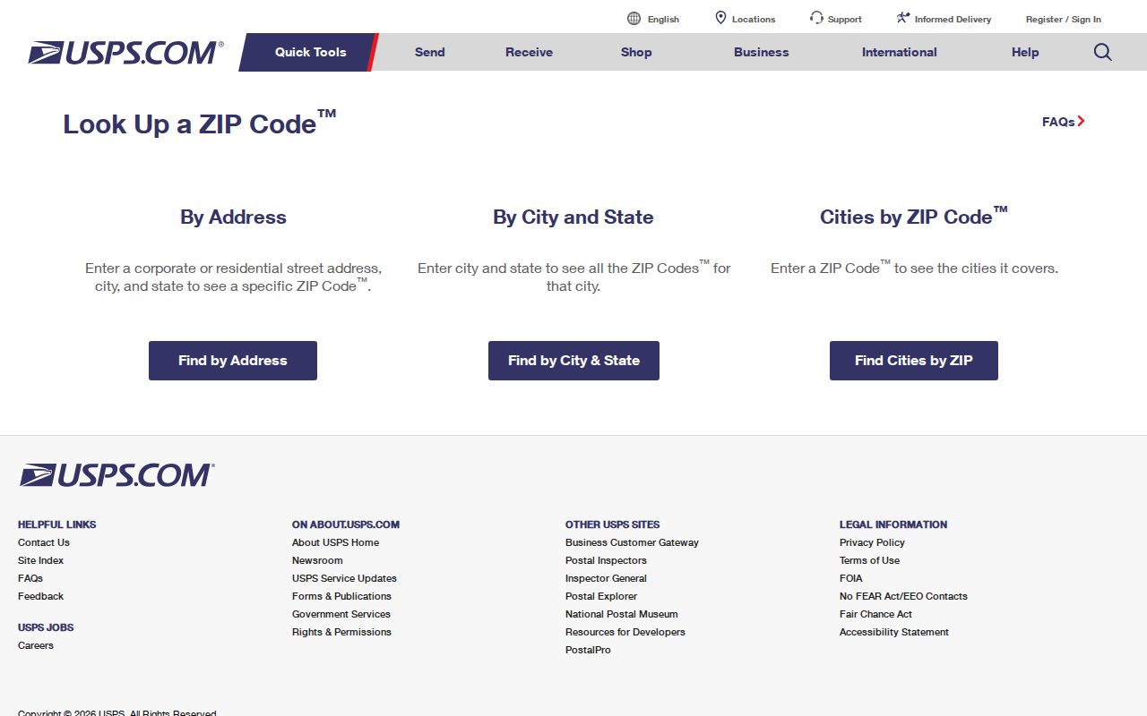
Use the address mode when a street location is known, city and state when a mailing place is known, and Cities by ZIP when starting from a five-digit code. USPS may show a preferred postal city even when local maps use a different community or place name. If a result matters for mail, check the full address rather than stopping at a map label.
| USPS Search Mode | Enter | What It Helps Confirm |
|---|---|---|
| Address lookup | Delivery address, city, and state | ZIP associated with a specific address. |
| City and state lookup | City or post-office name and state | Postal codes listed for the place name. |
| Cities by ZIP | Five-digit code | City or post-office names USPS associates with that code. |
Finding Hawaiʻi Residents by ZIP
A ZIP can narrow a records question, but the research found no official public search that returns a list of Hawaiʻi residents by ZIP. County property systems usually begin with an address, owner, map, or TMK, and election figures are organized by precinct or district. A sound process confirms the mailing area first, then moves to a record system that supports the needed field.
- Use USPS to check the full address or retrieve postal names for a known ZIP. Keep the returned post-office name as a mailing clue.
- Compare the address with the 2020 Census ZCTA layer or the Hawaiʻi DBEDT ZIP map sheets. Mark these as statistical geography, not proof of USPS delivery.
- For a property record, identify the physical address or parcel key. Honolulu records support address or TMK searches; Maui's portal lists location address, parcel/TMK, owner, map, sales search, and sales-list modes.
- Route the parcel to its county office. A map can help find a parcel, but the county tax or assessment record carries property information; some GIS layers show only parcel shape and TMK.
- For an election question, use precinct or district sources and the state registration service for your own status. Do not substitute a ZIP for a voter precinct or treat the voter service as a people directory.
Once a ZIP points to a community, a street-level question needs address evidence. The Hawaiʻi street directory follows that narrower parcel and street path. It can connect a known location with public property records, but neither a ZIP nor a parcel roll is a complete list of occupants.
Note: Precinct totals answer an election geography question, while a ZIP answers a postal routing question.
ZIP, ZIP+4, and ZCTA Terms
Postal codes, delivery routes, and census areas use related names but serve different purposes. These short definitions help keep a ZIP search from drifting into a claim the map or record cannot support.
- ZIP Code
- A USPS code used to sort and route mail. USPS confirms the valid delivery code for a particular address.
- ZIP+4
- The five-digit ZIP followed by four more digits. The added digits narrow delivery within a ZIP area, but they do not identify a resident.
- PO-box ZIP
- A ZIP used for post-office box delivery. A statistical map may have no ordinary street area for that code.
- Unique ZIP
- A code assigned to a single organization or institution. Census notes that such a code may not be represented by a regular area ZCTA.
- ZCTA
- A Census approximation built from census blocks to represent many ZIP delivery areas for statistics. It is not a USPS route map or a list of every valid code.
The Census Bureau says not every USPS ZIP has a ZCTA. A 2020 ZCTA may be noncontiguous, PO-box-only, unique to an institution, or extend outside a city or county boundary. Some valid postal codes may be absent from the table because they do not form a mapped statistical area. For delivery, use USPS; for a population map, use Census or DBEDT.
Hawaiʻi ZIPs Across the Islands
A county property system follows land jurisdiction: Maui County includes Maui, Molokaʻi, and Lānaʻi; Kauaʻi County includes Niʻihau even though the 2020 layer has no ZCTA addresses there. Kalaupapa falls in the Molokaʻi service group, while Kalawao is not a separate USPS county route. Post-office names may also differ from incorporated places.
For current postal status, USPS distributes a monthly City State Product through its PostalPro access system. Research did not locate a freely downloadable current Hawaiʻi-only list, so verify a live address instead of treating the 2020 map as current delivery data.
ZIP Codes and Hawaiʻi Place Boundaries
A ZIP is a mail-delivery assignment, not a city limit, county line, or statement of land ownership. Hawaiʻi addresses may combine a USPS city, island, district, subdivision, and parcel key without those labels matching. Special-use Oʻahu areas in the table include airport, military, institutional, and PO-box geography rather than ordinary neighborhood blocks.
The Census ZCTA guidance explains that statistical areas approximate many postal areas and do not cover every current USPS ZIP. State map sheets and the 2020 layer show geography; a county parcel lookup identifies the land custodian. Preserve the full address, island, county, and TMK when moving between those records.
Hawaiʻi ZIP Search Limits for Records
Most government systems are built around the record they keep, not around area-wide resident lookup. The Honolulu property record can use a site address or TMK, and a sales-history entry may point to a deed document number. Maui's property portal supports address, parcel/TMK, owner name, map, sales search, and sales-list modes. Hawaiʻi County's public GIS parcel layer holds shape and TMK, then the County Real Property Tax Office supplies property data. Kauaʻi has its own TMK and parcel tools.
| Property Search Field | Type | Required | Use or Limit |
|---|---|---|---|
| Site or location address | Text/autocomplete | Optional | Physical location; street abbreviations and unit numbers can affect results. |
| Owner name | Text | Optional | Honolulu and Maui explicitly support this mode; test name variants. |
| TMK / Parcel ID | Text | Optional | Stable parcel key; formats vary across Hawaiʻi counties. |
| Map | Map selection | Optional | Maui lists map search; identify a parcel before seeking its tax record. |
| Sales Search / Sales List | Tab or search mode | Optional | Maui FAQ lists both; Honolulu records expose sales history. |
| Assessment information | Result tab | Not applicable | Land and building data, class, assessed value, and exemptions. |
| Property description | Result section | Not applicable | Lot size, acreage, and building or improvement details. |
| Mailing address | Result field | Not applicable | May differ from the site address; availability varies by county. |
These modes answer a narrow property question after an address is known; they do not support an unsourced list of everyone living in a ZIP. A taxpayer mailing address may differ from the site address, and a home exemption is a tax classification, not proof of occupancy. Confirm a person only through a record that actually links that name and location.
Voter information is another distinct geography. Hawaiʻi's public fields are limited by law, and election records commonly use precinct or district rather than ZIP. The registration service confirms a voter's own status; it is not a public name-to-address directory. Do not read precinct totals as ZIP population.
Note: A useful ZIP search narrows where to look; the underlying address, parcel, or precinct record must answer the next question.